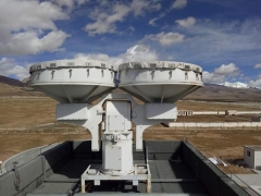
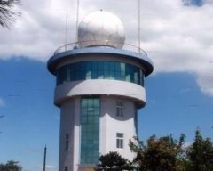
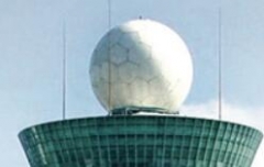
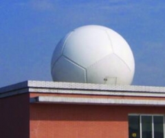
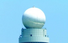
Weather radar is a radar specially used for atmospheric detection. It belongs to active microwave atmospheric remote sensing equipment. The high-altitude wind radar used in conjunction with the radiosonde is only a special device for positioning the displacement balloon, and is generally not regarded as this type of radar. Meteorological radar is one of the main detection tools for warning and forecasting of medium and small-scale weather systems (such as typhoons and storm clouds). Conventional radar devices are generally composed of directional antennas, transmitters, receivers, antenna controllers, displays and camera devices, electronic computers and image transmission. Meteorological radar is an important means of meteorological monitoring, and plays an extremely important role in sudden and disastrous monitoring, forecasting and warning
Meteorological Doppler radar operating in the 30-3000 MHz frequency band. Generally have a high detection sensitivity. Because the detection height range can reach 1-100 kilometers, it is also called middle-stratosphere-tropospheric radar (MST radar). It is mainly used to detect the vertical distribution of atmospheric dynamic parameters such as wind, atmospheric turbulence and atmospheric stability (see atmospheric static stability) in the clear sky atmosphere.
Weather radars use a wide range of radio wavelengths, from 1 cm to 1000 cm. They are often divided into different bands to represent the main functions of the radar. The wavelengths of 1, 3, 5, 10 and 20 cm commonly used by meteorological radars correspond to K-band (wavelength 0.75-2.4 cm), X-band (wavelength 2.4-3.75 cm), C-band (wavelength 3.75-7.5 cm), S-band (wavelength 7.5-15 cm) and L-band (wavelength 15-30 cm). 000 cm. The performance of radar detecting atmospheric targets is closely related to its working wavelength. Considering the scattering and absorption of radio waves by cloud and rain particles, various wave bands have only a certain range of application. The K-band radar is commonly used to detect various clouds that do not produce precipitation, and the X, C and S-band radars are used to detect precipitation. The S-band is most suitable for detecting heavy rain and hail, and the high-sensitivity UHF and VHF radars can detect the troposphere-stratosphere-middle-level clear-air flow field.
Any radar that does not have Doppler performance is called non-coherent radar or conventional weather radar, and radar with Doppler performance is called coherent radar or Doppler radar.
The main weather radars are:
Cloud radar. It is a radar used to detect the height, thickness and physical characteristics of clouds without precipitation. Its commonly used wavelength is 1.25 cm or 0.86 cm. The working principle is the same as the rain radar, mainly used to detect the height of cloud top and cloud base. If there are multiple layers of clouds in the sky, it can also measure the height of each layer. Because cloud particles are smaller than precipitation particles, the working wavelength of cloud radar is relatively short. Cloud radar can only detect altostratus and mesostratus with relatively few clouds. For low-level clouds with large water content, such as cumulonimbus, hail, etc., the beam of cloud radar is difficult to penetrate, so it can only be detected by rain radar.
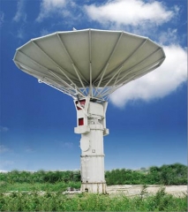
Rain radar. Also known as weather radar, it uses the scattering of electromagnetic waves by raindrops, cloud droplets, ice crystals, and snowflakes to detect the concentration, distribution, movement, and evolution of precipitation in the atmosphere or large droplets in clouds, and to understand the structure and characteristics of weather systems. The rain radar can detect typhoons, strong storms in local areas, hail, heavy rain and strong convective clouds, etc., and can monitor weather changes.
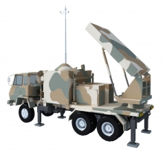
Wind radar. It is used to detect the horizontal wind direction, wind speed, air pressure, temperature, humidity and other meteorological elements in different atmospheric layers at high altitude. The detection method of wind measuring radar is generally to use tracking reflectors or transponders hanging on the balloon to continuously locate the balloon. According to the displacement of the balloon per unit time, the horizontal wind direction and wind speed of different atmospheric layers can be determined. At the same time, a radiosonde is hung on the balloon to remotely measure the air pressure, temperature and humidity in the upper air.
Circularly polarized radar. General weather radars emit horizontally polarized waves or vertically polarized waves, while circularly polarized radars emit circularly polarized waves. When the radar emits circularly polarized waves, the echoes of spherical raindrops will be circularly polarized waves that rotate in the opposite direction, while non-spherical large particles (such as hail) will cause depolarization to circularly polarized waves. Using the echo characteristics of the depolarization properties of non-spherical hailstones, circularly polarized radars can be used to identify whether there is hail in a storm.
FM continuous wave radar. It is a radar that detects the atmosphere in the boundary layer. It has extremely high distance resolution and sensitivity, and is mainly used to measure fluctuations, winds and turbulence in the clear-air atmosphere in the boundary layer (see Atmospheric Boundary Layer).
Meteorological Doppler Radar. A radar that uses the Doppler effect to measure the radial velocity of cloud and precipitation particles relative to the radar.
VHF and UHF Doppler radars. Utilizing the inhomogeneous structure of the refractive index of the troposphere and stratosphere and the scattering of free electrons in the middle atmosphere, it is a radar that detects the horizontal wind profile, vertical airflow profile, atmospheric turbulence parameters, atmospheric stable stratification and atmospheric fluctuations in the clear sky at an altitude of 1 to 100 kilometers.
There are also dual-wavelength radars and airborne Doppler radars in the research and test radars. Since the 1970s, the new development of synthetic aperture radar, which uses a moving small antenna to be equivalent to a large antenna synthesized by many stationary small antennas, will definitely accelerate the development process of airborne Doppler radar in the future. Airborne Doppler radars are highly mobile and can be used to obtain high-resolution Doppler velocity profiles of convective storms.